Pilots use many materials to help them be successful at what they do. Whether a pilot is transporting people, cargo, or is just flying for fun, every pilot has certain materials to help them. A handful of these materials are mandatory to fly with, while other are not mandated, but extremely useful. These materials include books, maps, and tools for flight planning purposes. This page explains some of the more common materials pilots use to navigate the skies.
Aeronautical Charts
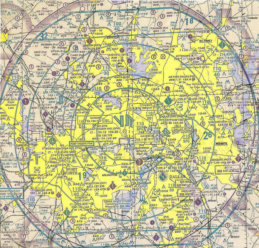
Aeronautical charts are maps designed to help pilots navigate aircraft along the ground. The three types of charts have differing amounts of detail and are used when traveling certain distances. The charts contain the land for the area the map covers as well as landmarks that pilots can use for navigation. Landmarks include major roads, rivers, lakes, tall buildings, racetracks, railroads and more. In addition to the navigation landmarks, the charts show areas of airspace, their altitude, airports, radio navigation stations, and Victor airways. The picture to the right shows the class B airspace surrounding Dallas Fort Worth Airport, Texas. In the picture, you can easily see the blue rings, which denote the airspace, the layout of the runways, surrounding runways, and landmarks with their height displayed next to them. All types of aeronautical charts are updated every 6 months. For more information about the symbology used on aeronautical charts, click here
Terminal - TAC
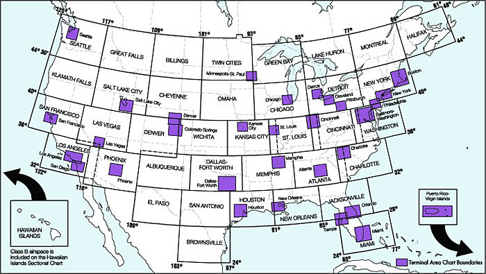
The Terminal Aeronautical chart covers the smallest amount of area, but shows the greatest amount of detail. Terminal charts, or the TAC, don not cover the entire United States, and are used in areas with high amounts of air traffic, and surrounding the nation’s busiest airports. The scale of the terminal chart is 1:250,000. When pilots enter an area of heavy traffic, using TACs allow them to navigate more safely. The picture to the right shows all the terminal chart areas in the United States. The smaller purple, shaded rectangles represent terminal chart coverage.
Sectional - SAC
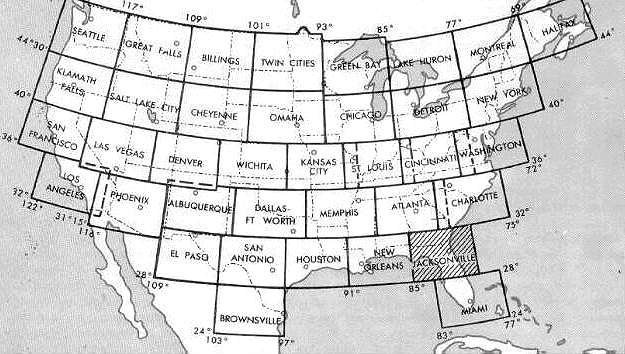
The Sectional area chart, or SAC, shows less detail than the terminal area chart, but provides a greater area for navigation. The scale of the SAC is 1:500,000. Unlike the terminal charts, the sectionals cover the entire United States. The picture to the right shows the different areas of sectional chart coverage. It’s common that one sectional shows more than one state’s airspace. It’s important to know that TAC charts reside within sectional charts. The difference being that the terminal chart is a “magnified” view of a specific region within the sectional chart
World - WAC
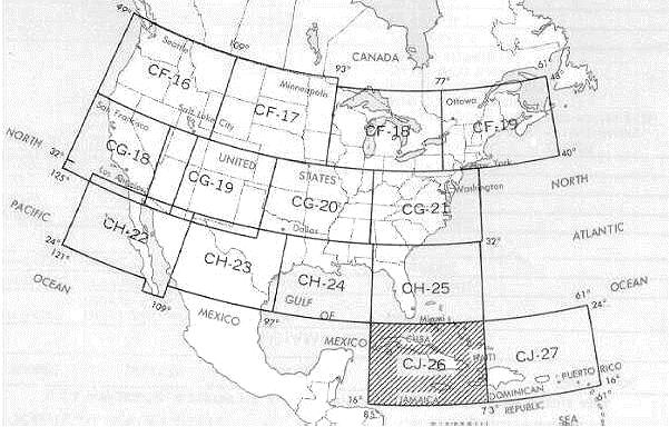
The World aeronautical charts cover the greatest areas. The scale of the WAC chart is 1:1,000,000. The picture to the right shows that only a few WAC charts cover the entire United States. Because of the low amount of detail, compared to the TAC and SAC charts, the WAC charts omit many landmarks such as railroads, highways, and smaller lakes. This is because pilots who use world charts are flying much higher and faster than pilots who would be using a TAC or SAC chart. Because of this, WAC charts are rarely used for VFR flights, and are used for planning out longer flights. In the United States, the WAC charts are revised annual, instead of biannually.
Federal Aviation Regulations/ Aeronautical Information Manual
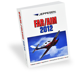
The FAR/AIM book is actually two separate books, bound into one publication. The first book, the Federal Aviation Regulations, is the set of rules which govern all aviation within the United States. Everything pilots need to know about regulations, laws and rules can be found in the many different parts of the FAR. Everything from flight schools, to the definition of a hot air balloon to how old a passenger must be to buy their own ticket on an airplane, can be found there.
The second book, the Aeronautical Information Manual, is the official guide to basic flight information and Air Traffic Control procedures. The book contains a glossary, procedures for Instrument flight, and terms to use when talking to ATC, among other things. The FAR/AIM is published every year, and flying without a current edition is breaking a federal aviation regulation.
The second book, the Aeronautical Information Manual, is the official guide to basic flight information and Air Traffic Control procedures. The book contains a glossary, procedures for Instrument flight, and terms to use when talking to ATC, among other things. The FAR/AIM is published every year, and flying without a current edition is breaking a federal aviation regulation.
Airport/ Facility Directory
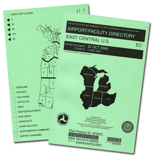
The book which contains all the information on airports located within a specified region is the Airport/Facility Directory, or the A/FD. The information provided within the A/FD about a certain airport is the runway information (length, width, surface and traffic pattern) frequencies for communication (tower, ground, approach and departure) Instrument approach and departure procedures, as well as remarks about the airport (such as flooding tendencies and bird activity) radio navigation aids, as well as the airport diagram. In addition to airport information, all radio navigation stations are included in the A/FD. These include NDBs, as well as VORs. The airports and radio navigation stations are listed alphabetically with one another, segregated by state within the region. Every A/FD is updated every 56 days.
Logbook
The Logbook is one of, if not the most vital documents a pilot can posses. The logbook keeps track of every single flight a pilot does. The logs include the duration of the flight, who the pilot in command was, where the flight departed from, where it arrived, the type of flight (VFR or IFR) instrument work, number of landings, and a signature section. All this information is logged the by PIC of the flight. For student pilots not doing solo flights, the instructor fills out the log book. When the student or a pilot with a license flies, they’re the ones who fill out the log for that flight. When applying for most pilot jobs, employers request to see a candidate’s logbook. It’s important to keep you’re logbook neat, organized, and up to date.
Checklists
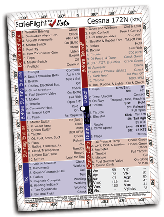
A checklist is a list of items that one must remember to do. This is no different in aviation. Pilots are provided with checklists by manufacturers to make sure the proper use of the airplane is met. Checklists are used in many phases of flight, which include, before engine start, engine start, before taxi, before takeoff, climb, cruise, descend, pre-landing, after landing, and shutdown or secure. Checklists ensure that pilots don’t miss anything that needs to be done for proper operation of the aircraft. An example of a checklist is as follows:
Climb checklist
Climb power………….......set
Mixture control….............full enrich
Electric fuel pump…........off
Flaps..........................…verify retracted/0°
Climb checklist……….....complete
Each phase of flight checklist has different items the pilot must perform. It’s not uncommon to have to do a checklist every few minutes while flying an airplane.
Textbooks
Several companies, including the FAA, publish textbooks for student to use to help learn everything there is to know about aviation. Learning the terms, phrases and vocabulary associated with flying can be like learning a completely new language. Textbooks vary in detail and some can be as long as 800 pages. A common company in the aviation industry is Jeppesen. The company creates textbooks, aeronautical charts, approach plates, and gadgets. The book on the lower left is the private pilot textbook. It is one of the most popular books used at flights schools across the country. The book in the middle is issued by the FAA and is similar to the Jeppesen book, but goes into a little more detail. The book on the lower rights is very similar to the book issued by the FAA, but is laid out in a different manor. All three books contain everything student pilots need to know when going for their license.
|
|
|
Pilot Operating Handbook
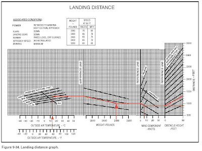
The Pilot Operating Handbook, or POH is a mandatory book pilots must have onboard an aircraft in order to operate that aircraft legally. The POH is essentially the airplane’s manual. Everything an owner or operator needs to know about the plane to be flown can be found in the POH. Performance charts, such as takeoff distances, cruise power, gliding distance, landing rolls and fuel consumption rate is found in the POH. In addition to the vital performance information, the POH contains all the specific information to the airplane. For example, the POH explains which types of wheels the airplane has, the struts on the gear, and the material which makes up the fuselage. Even the turning radius of the nose wheel is included in the POH. An aircraft’s Pilot Operating Handbook is vital to the safe operation of an aircraft and is needed every time the aircraft is to be flown.
The picture to the right is an example of a chart found in a POH. This chart, when followed correctly, will tell the pilot exactly how long the takeoff run will take before the airplane rotates.
The picture to the right is an example of a chart found in a POH. This chart, when followed correctly, will tell the pilot exactly how long the takeoff run will take before the airplane rotates.
Duats Account
DUAT stands for Direct User Access Terminal and are internet websites which provide an inordinate amount of weather information for pilots. To set up a DUAT account, pilots or student pilot, fill out a short form on the website, using their certification number, or medical number. This allows them to access invaluable information on the current and forecasted weather before going on a flight. Before planning a flight, pilots log onto their account, and search for weather within the area they’re planning on flying in. They have access to charts, current weather, forecasted weather, maps, in flight weather reports, and other tools which help them determine if their flight can be made safely. There are currently two different DUAT websites available. The first is www.duat.com and the other is www.duats.com. Both websites provide the same information and are useful for flight planning
E6B Flight Computer
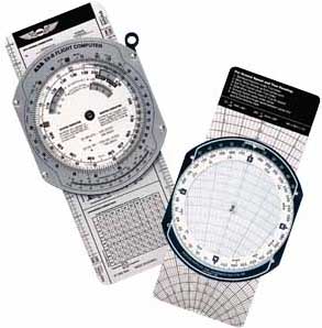
The E6B flight computer, commonly referred to as the whiz wheel, is a tool pilots use for many different functions. The flight computer has two sides, a wind correction angle side and a computation side. The wind correction side helps pilots determine the correct amount of wind correction needed when flying at a certain heading with certain wind conditions. The front side, or the computer side, helps pilots make calculations without the need to do pencil and paper calculations. This side can perform many functions such as determine density altitude, convert Fahrenheit to Celsius, determine the distance in nautical miles versus statue miles, and even act as a calculator for basic addition, subtraction, multiplication, and division problems.
Flight computers come in both the basic whiz wheeled form, as seen in the picture at right, and the calculator version, an electronic devise which does computations for the user.
Flight computers come in both the basic whiz wheeled form, as seen in the picture at right, and the calculator version, an electronic devise which does computations for the user.
Plotter
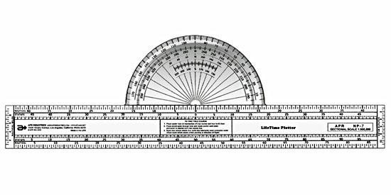
The plotter is an essential tool for VFR flight planning. During flight planning, pilots plot a course on the aeronautical chart. The course involves selecting waypoints in order to reach the destination. The plotter measures distances between waypoints, and determines the true course from point to point. This tool isn’t mandated by the FAA, but it’s very beneficial to pilots flying cross country flights.
