Today I prepared for my first cross country flight. Before students start going on cross country training flights, they first must understand what they’re doing. It would be pointless flying to a different airport if the student didn’t know how they got there or what the procedures were for cross country flight. Today, my instructor showed me what I need to do prior to the flight, in order to get ready for a cross country flight lesson
Pilotage and Dead Recogning
First off, there are many ways which pilots navigate the skies. A common, well know method is by GPS. GPS has become standard in all new built aircraft. However, plane which were built in the 1960s are still being flown all over the country today. While some pilots spend money to have GPS systems installed on older aircraft, most planes from decades ago must rely on other means of navigation. During VFR flight, the standard way to navigate is by pilotage and dead recogning. Pilotage is the process of navigating by visual references on the ground. For example, a pilot flies until he sees a point which can be seen on his map. This can be a building, a road, bridge, or anything distinguishable. Once the pilot locates the object on his chart, he knows where he is. Then, he’ll fly in the direction of another known marker and continue to do so until he reaches his destination. Dead recogning is the process of adding math to pilotage. By knowing speed, altitude, winds, and distances, pilots can know when they will be over a known location at the precise moment they reach it. Dead recogning is how private pilots are trained at Farmingdale Aerospace, along with student pilots all over the country.
Navigation Log All time, distance, fuel, altitude and other pertinent information is recorded on a navigation log. The first thing on the log is an area where the pilot can write down waypoints. This can be anything from an airport or VOR to a bridge, intersection of roads, or buildings. Almost anything can be used as a waypoint, as long as it’s clearly visible from the desired altitude and if it sticks out from its’ surroundings. The goal is to get from one airport to another as directly as possible. It’s advantageous to pick waypoints which make the most direct line possible between the two airports. Of course, the majority of the time, the flight won’t be straight and will “zig zag” a bit. During my lesson today, I filled out a mock navigation log, which would have taken me from Republic Airport to Dutches County Airport in Poughkeepsie, NY. Including the starting and ending airports, I had 7 total waypoints. Once I decided on suitable waypoints, I measured the distance in, NM, from waypoint to waypoint. Because winds play a vital role on timing and correction angles, you need to compensate for wind when determining the true course from one waypoint to the other. It’s also important to note that when planning for winds, pilots must use the winds aloft data, and not surface winds. Once winds correction angles had been established, I then compensated for variation. Variation is the angular difference between geographical North Pole and the magnetic north pole. In my area of New York, the variation is about 14°W; so I add 14 to my true course (east is least, west is best). Next was magnetic heading. This is the final heading | 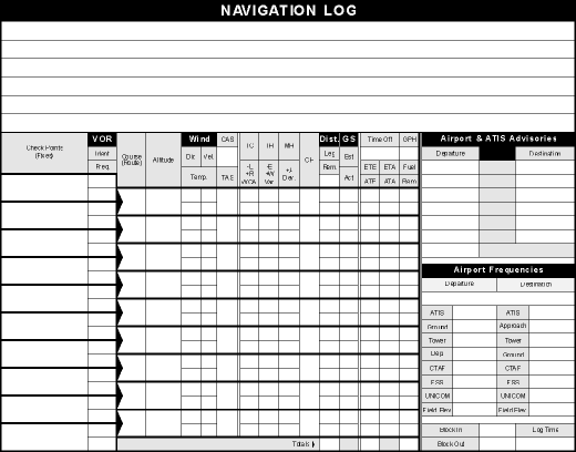
|
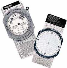
which the nose of the plane should be pointed in order to arrive at the desired waypoint. In order to get this, I had to add or subtract deviation. Deviation is the error in the heading indicator due to the magnetic and electrical fields inside the plane (often caused by the instruments, GPS, cell phones etc.). Normally, there isn’t more than 1 or 2 degree deviation for each radial. Any wind, time, fuel and distance can be calculated by using a “Whiz Wheel.” A Whiz Wheel (above) is a flight computer; one side has a tool which allows for wind angle correct, while the other side has two turnable wheels for computations.
Once the magnetic heading was established, I needed to find out fuel consumption. In order to do this, I needed to know how much fuel the airplane would burn. Luckily, that information’s provided in the aircraft’s POH. Because I know what my speed will be, and the distances between waypoints, I can calculate exactly what time I should be at each way point. Also, because I know the distance and the fuel consumption rate, I can calculate the amount, in either pounds or gallons of fuel the trip will need.
The last section on the navigation log is for additional information. There are spots to write down both the departure and the destination airports’ frequencies; tower, ground, ATIS, FSS, and any other frequencies, which are important.
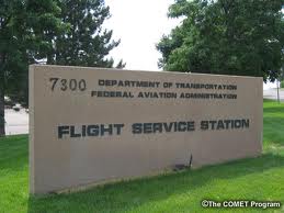
Once completed, the pilot then needs to call the appropriate flight service station to open the flight plan. This means that the pilot puts his trip on record. Once airborne, or just prior to takeoff, the pilot will open the flight plan so the flight service station knows the plan is active. Once the trip has been completed and the destination airport is reached, the pilot must close the flight plan. If not closed, the FSS will issue a search and rescue operation after 15 minutes of expected time of arrival at the destination airport. Because today was practice, I didn’t open the flight plan. However, it was good practice for my first cross country flight next week.
