Today was the first time I flew the simulator. The flight school has a large room with flight simulators in them for the students to use. There are pros and cons with using the sims. First off, using the sim as a lesson is much cheaper than a plane. There’s no fuel, and landing fees. Another pro is that there’s no danger, like when flying an airplane. However, the feel of using the sim is not even close to the feel of a real airplane. While piloting the sim, there is pressure on the yolk, like in a real plane, but it is infrequent and can’t be relied on to know what the plane wants to do. The instruments are extremely sensitive also, which makes it hard to stay on a specific heading and altitude for an extended period of time. What the simulator is good for is what I did today; practicing VOR navigation.
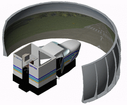
Computer image of what the simulator looks like.
VOR navigation is a way to know where you’re going, while flying. Simply put, VORs are stations on the ground, which emit a signal in all directions. The signal is picked up by the transponder in the airplane and displays data in the cockpit. Basically, the plane will track a signal from the VOR. Then the pilot can fly on a specified heading to or away from the VOR station, and know where he or she is.
I was using the largest and most expensive simulator today. There’s a real sized cockpit in the room with a 180 degree screen in front of it which displays a picture of what I would see if I was actually flying outside. All geographical landmarks, airports, VORs, and other navigation aids are 100% accurate in the simulator, compared to reality.
When the sim turned on, I was already lined up with the runway. Instructors don’t really care about taxiing and contacting tower while using the sim. I used the throttle to accelerate, and took off, trying to maintain what I would do in a real flight. (climb out at Vy, and keep a heading of the centerline) When I got to 2000 feet I leveled off as best as I could, and assessed my flight so far
First, my instructor told me how to use the GPS to find the nearest VORs to me. I found the closest one, deer park, and noted the frequency. With my instructor’s help, I put in the frequency, and listened to the Morse code. After confirming the Morse code signal, I turned the needle on the VOR instrument in the cockpit, until it was lined up with the center line. If the line moves left or right, that means I’m off course. From turning the CDI knob, I read a heading of 165. I flew this course and eventually intersected the course I needed to fly in order to get to the VOR. Unfortunately, I still need more practice using VORs. My instructor had to help me a lot while flying. I practiced tuning to 2 more VORs before trying to figure out the GPS
The GPS is much simpler to use, and contains more information. The GPS has many functions, but one of them is that a pilot can use it just like a VOR. The only difference is that the VOR is digitally displayed on the GPS interface instead of on an analogue dial. Another function of the GPS is that it can tune into more than just VOR signals, or stations. There is a database pre-programmed into the GPS system that has a lot of waypoints that the GPS can also tune into. The advantage of this is that the GPS isn’t limited to what it can identify. Instead of tuning into a VOR’s signal, we tuned into Republic airport’s signal. The GPS automatically identified the station and displayed a direct route to the field. Because I was in a simulator, airspace was no factor. (no factor is a term used in aviation which means it doesn’t matter. For example, often while on final approach over 3 miles out, the tower will tell me that another plane is going to be taking off before I land. After the airplane on the ground takes off, the tower will radio to me and say that the traffic is no factor; meaning the taking off airplane doesn’t pose a problem to my landing)I made an ok landing, not bad for a simulation, and turned the machine off. Hopefully next lesson, in two days, I’ll be able to fly a real airplane and practice VOR navigation.
